Tourism License No.: 1210/072 | Govt. Regd. No.: 2145
-
Email us at
-
Call us now +977 1 4412856, 4420838
Mount Kailash - 16 Days
-
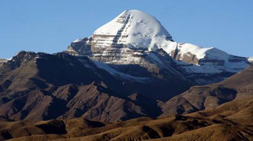 Mount Kailash
- Destination: Nepal
- Duration: 16 Days
- Trip Grade: Very Strenuous
- Min person: 2
About Trip:
An adventurous and spiritual journey which covers most of the best parts of Tibet. Truly a fabulous journey which offers awesomely beautiful rock formation, cascades and canyons slightly hidden under the thin mists. With numerous high passes with stunning views of the picturesque landscape, tranquil lakes, rural villages, large meadows with nomad camps scattered all around the overland trip is one of the best in short duration. Enriched by the ancient most lavishly decorated monasteries and temples with chanting saffron colored monks, ever smiling faces of people and their typical lifestyle all contributes to this trip a memory of your lifetime. A land so rich in culture, tradition and steeped in religion with its unique landscape cast an enchanted spell that holds you in thrill and excitement.
Mount Kailash,situated within Tibet to the Northern part of the Himalaya.It is the spiritual center for four great religions: Tibetan Buddhism, Hinduism, the Jain religion and the pre-Buddhist animistic religion – the Bonpo. And strangely enough, four major rivers i.e. the Karnali, Sutlej, Indus and the longest one – Brahmaputra, originate from near Kailash mountain. For the Tibetans it is a particularly special place, the poet saint, Milarepa, spent several years here meditating in a cave.
For the Hindus Mount Kailash is the earthly manifestation of their spiritual center of the universe, ‘world pillar’ around which all else revolves, its roots in the lowest hell and its summit kissing the heavens and on top lives their most revered God Shiva. The governments of Nepal and China reached an accord 3 years ago, that allowed the first treks across the border between the two countries. While it had been a route for Nepalese pilgrims for years, the foreign trekkers were never allowed to trek from Nepal to Tibet.
Mt. Kailash 6,714m / 22,028ft is situated to the north of the Himalayan barrier, wholly within Tibet. It is the perfect mountain with awesome beauty, with four great faces, the eastern face is believed to be crystal, the western ruby, the southern sapphire and the northern gold. It is the spiritual centre for four great religions: Tibetan Buddhism, Hinduism, the Jain religion and the pre-Buddhist animistic religion-Bonpo. To Tibetans it is known as Ghang Rimpoche(Precious Jewel of Snow) and they see it as the naval of the world. It is said that a stream from the mountain pours into a nearby lake and from here rivers flow in the four cardinal directions.
The river of the Lion Mouth to the North, the River of the Horse Mouth to the East, the River of the Peacock Mouth to the south and the River of the Elephant Mouth to the West. It is really fascinating to know that, the four major river system of the Indian Sub-Continent originate near Kailash, the Indus, the Yarlung Tsangpo (Brahmaputra), the Karnali and the Sutlej. Tibetans believe that it is the residence of Demchog, a fierce looking tantric deity who lives there with his consort, Dorje Phagmo. From the early days up till now for the Tibetans and Buddhism it is more than a holy place, as their great poet, tantric saint Milarepa spent several years meditating in cave around the Mt. Kailash area.
For the Hindus…their spiritual centre of the universe, described as a fantastic ‘world pillar’ 84,000 miles high, around which all else revolves, its root in the lowest hell and its summit reaching the heaven and the abode of their revered God Shiva and his consort Goddess Parvati.
For the pre-ancient religion Bon, it is the site where its founder Shanrab is said to have descended from heaven and it was formerly the spiritual centre of Zhang Zung, the ancient Bon empire that once included all western Tibet. Bon people circumambulate this holy mountain in an anti-clockwise manner, unlike the other religion does it clockwise.
Over the centuries, pilgrims from all corners of the world, have constantly journeyed immense distances to achieve enlightenment or cleanse themselves from sins, braving enormous distances, particularly harsh weather and bandit attacks.THE NGARI- in Tibet. From Saga, Paryang-Darchen onwards to Ali.
Kailash and Manasarover are in the Ngari region of Tibet, in the past it used to be the most inaccessible place on earth. This region is mostly populated by Dokpas, nomads who herd sheep, goats and yaks on these arid desolate plains, Most Dokpas do not have houses and they wander endlessly across the vast Tibetan windswept plains, living in yak hair tents. Ngari is the last frontier of Tibet: On this trip, after leaving Kathmandu and other cities on route you feel as if you had suddenly transported back in the past even early than Marco-Polo times.
Trip Highlights
“exotic, cultural & scenic adventure through south-west Tibet to Mt.Kailash”
Outline itinerary
Day 1:Arrive Kathmandu.1,300m via respective airlines
Day 2:Half Day sightseeing tour in Kathmandu
Day 3:Kathmandu (1,300m)-Zangmu(2,300m)-Nylam (3, 650m)
Day 4:At Nylam for acclimatisation
Day 5:Drive to Saga. Approx. 4,300m. or camp on route. 5-6 hrs journey
Day 6:Drive to Paryang. Approx. 4,450m. 5-6 hrs
Day 7:Drive to Manasarover near Horpa. 4,510m. 6-7 hrs ride
Day 8:Parikrama of Lake Manasarover and drive to Darchen. 4,600m
Day 9:Drive to Darchen 4,600m visit Sherlung Monastery and Nandi Parbat or Astha Padha especially for Jain religion
Day 10:Trek to Dhirapuk. Approx. 4,800m. 4-5 hrs
Day 11:Trek over Droma-la & Camp at Lamche Valley.approx. 4,700m
Day 12:Trek to Darchen and drive to Paryang. Approx: 3-4 hr walk. and 5-6 hrs drive
Day 13:Drive to Saga. 5-6 hrs. ride
Day 14:Drive to Nylam 5-6 hours
Day 15:Drive back to Kathmandu
Day 16:Depart Kathmandu via respective airlines
Detail Itinerary
Day 1Arrive Kathmandu.1,300m via respective airlines
Day 2Half Day sightseeing tour in Kathmandu
Day 3Kathmandu (1,300m)-Zangmu(2,300m)-Nylam (3, 650m)
Day 4At Nylam for acclimatisation
Day 5Drive to Saga. Approx. 4,300m. or camp on route. 5-6 hrs journey
Day 6Drive to Paryang. Approx. 4,450m. 5-6 hrs
Day 7Drive to Manasarover near Horpa. 4,510m. 6-7 hrs ride
Day 8Parikrama of Lake Manasarover and drive to Darchen. 4,600m
Day 9Drive to Darchen 4,600m visit Sherlung Monastery and Nandi Parbat or Astha Padha especially for Jain religion
Day 10Trek to Dhirapuk. Approx. 4,800m. 4-5 hrs
Day 11Trek over Droma-la & Camp at Lamche Valley.approx. 4,700m
Day 12Trek to Darchen and drive to Paryang. Approx: 3-4 hr walk. and 5-6 hrs drive
Day 13Drive to Saga. 5-6 hrs. ride
Day 14Drive to Nylam 5-6 hours
Day 15Drive back to Kathmandu
Day 16Depart Kathmandu via respective airlines
Equipments List
Clothing’s:
• Hiking boots
• Socks
• Trekking trousers and pants
• Under Garments
• Hiking shorts
• T-shirts
• Fleece jacket or pullover
• Waterproof jacket
• Sun hat or scarf
• Warm hat
• Sunglasses with UV protection
• Thermal gloves
• Thermo rest
• Headlamp or head torch with spare bulbs and
• batteries
• Daypack (approximately 2500 to 3000 cubic
• inches)
• Trekking Poles
• Basic First Aid Kit
• Water bottles
• Toiletries (Small wash towel, Toilet papers, Tooth
• brush/paste etc)
• Ear Plug (who know some people on group may
• snore)
• Deodorants
• Face and body moisturizer
• Feminine hygiene products
• Tissue /toilet roll
• Anti bacterial hands wash
• Reading book & note book
• Walkman or any other music gadgets
• Swimming customs (for the hotel pool in
• Kathmandu)
• Extra clothes to wear in Kathmandu, when you
• come back from Trek
• The gears in the list below are also provided by
• Himalaya Hikes as a part of your package but if you
• prefer to use your own private piece, we encourage
• you to bring your own.
• Down vest and/or jacket
• 4 or 5 season sleeping bag rated to - 20 degrees
• Trekking Bags/Duffel bag
• Carry mat
Trip Note
The above itinerary should be taken only as a guide line; since we will be trekking on some of the most remote terrain on earth, it could change due to weather, availability of clean water and campsite, trail or any other unforeseen conditions. In the event of this happening, your senior guide will make the final decision after consulting with the group.